
1873 Book
Atlas of Long Island, New York published by Beers, Comstock and Cline.
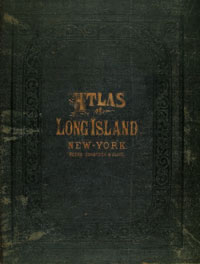
The Atlas of Long Island created by Frederick W. Beers in association with Comstock and Cline was published in 1873. The atlas was originally created to visualize land boundaries to determine property taxes. This ambitious project became the first comprehensive atlas of Long Island and the Metro New York area. The leather bound atlas measuring 15 5/8 x 14 inches has both an embossed gilt cover and an impressive engraved title page. The atlas contains many detailed maps of Long Island and Manhattan. It contains 45 pages of letterpress text pertaining to the individual maps and a total of 47 maps, many with multiple folds and multiple images. There are 176 different towns represented overall in the book, with various communities colored in shades of yellow, pink and green. Within each of these maps, property lines are drawn along each individual plot. Next to each plot the family name of a known owner is printed. Highways, railroads, and various important roadways are depicted in detail throughout. The maps were printed with letterpress text either within the image or on its verso. Some of the more fascinating aspects of the book are the 52 x 14 inch map of Long Island, as well as maps of Manhattan, Staten Island, Hudson County in New Jersey, and detailed representations of both Nassau and Suffolk Counties. Other larger maps of interest are the maps of New York State, Flushing, Jamaica, Oyster Bay, Hempstead, and the Hamptons. F.W. Beers came from a family of publishers. While in school, Frederick, his cousin Silas N. Beers and their friend D. Jackson Lake, studied under the mapmaker J. H. French, at Newtown Academy in Newtown, Connecticut. When French left the Academy in 1855 to pursue a position with the New York State Mapping project he took his three former students as associates. The project, said to be the most notable mapping accomplishment of any state at that time, was the training ground for the three young mapmakers.
Bibliography
W. Ristow, American Maps and Mapmakers: Commercial Cartography in the Nineteenth Century, Detroit, 1985; D. Allen, Long Island Maps and their Makers: Five Centuries of Cartographic History, New York, 1997; George Glazer Gallery, Frederick Beers Map of Long Island: from Atlas of Long Island, New York, 1873, available at http://www.georgeglazer.com/maps/newyorkmaps.beerslongisland.html [accessed 2 January 2006]; Antiquarian Booksellers Association of America, Atlas of Long Island, available at http://abaa.org/dbp/detail.php?booknr=247795021 [accessed 1 February 2006]; Rare Maps, available at http://www.raremaps.com/cgi-bin/map-builder.cgi?America+Northeast+10176 [accessed 12 January 2006]; Antiquarian Booksellers Association of America, Oneida Map, available at http://www.aba.org/dbp/catalogues.php?catnr=797&membernr=1700 [accessed 12 January 2006]. |
A Digital Initiatives Project
Long Island University, C.W. Post Campus