1795 Map
New York State Map by Samuel Lewis
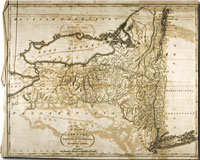
This map of The State of New York is inscribed with the following, Compiled from the Best Authorities~ By Samuel Lewis. 1795. Samuel Lewis was a famous American geographer and cartographer and an extremely important figure in early American mapmaking. In the late 18th century, Lewis worked for Mathew Carey, a well-known publisher in Philadelphia who had emigrated from Dublin in 1784. Carey began his work in Philadelphia by setting up a business with funds donated to him by the Marquis de Lafayette, who he had met while visiting France. In 1795, Carey published an American edition of the atlas, Guthrie's Geography Improved. Many of the maps contained in this atlas appeared again in Carey's American Atlas, which was the first atlas of America published in this country. The map of The State of New York from the CSHS Collection is similar to other maps that are believed to have been part of Carey's American Atlas. Thus, it is probable that the CSHS map of New York State was originally part of this publication. In 1804, Lewis formed a partnership with Aaron Arrowsmith, an English publisher who produced atlases and independent maps. Some of Lewis' most important work was related to the Expedition of Meriwether Lewis and William Clark. Clark created a map based on their discoveries that depicted the true positioning of the Missouri and Columbia Rivers, showed the complexity of the Rocky Mountains, and debunked the myth of the existence of the Northwest Passage. Nicholas Biddle, who was working on a history of the Lewis and Clark Expedition, gave Clark's map to Samuel Lewis to copy. In 1814, the map was published under the title of, "A Map of Lewis and Clark's Tracks across the Western Portion of North America."
Selected Bibliography
E. Bradsher, Mathew Carey, Editor, Author and Publisher: A Study in American Literary Development. New York, 1966; W. Gerdts, A Deception Unmasked; An Artist Uncovered. American Art Journal, 18:2, 1986, 4-23; A. Lemmon, et al. Charting Louisiana: Five Hundred Years of Maps. New Orleans, 2003; E. Raisz, Outline of the History of American Cartography. Isis. 26:2, 1937, 373-391. |
A Digital Initiatives Project
Long Island University, C.W. Post Campus